beautypg.com
Manuals
Brands
Garmin Manuals
GPS
AERA 660
Garmin AERA 660 Manuals
Manuals and User Guides for Garmin AERA 660. We have
4
Garmin AERA 660 manuals available for free PDF download: Pilot's Manual, Quick Reference Manual, Quick Start Manual
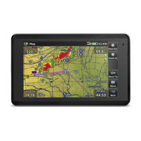
Garmin AERA 660 Pilot's Manual (244 pages)
Brand:
Garmin
| Category:
Car Navigation system
| Size: 8.59 MB
Table of Contents
Table of Contents
13
Section 1 Overview
17
Unit Overview
17
Getting Started
18
Battery Installation
18
Charging the Battery
19
Mounting the Aera 660 in the Aircraft
20
Turning the Unit On/Off
20
Receiver Status
20
Display Orientation
22
Operation
23
Basic Touchscreen Operation
23
Dedicated Page Icons
24
Main Menu
26
Accessing System Functionality
31
Option Menus
31
Data Entry
32
Quick Settings Page
34
Title Bar Timer
34
Using Map Displays
35
Map Range
35
Map Panning
37
Map Overlays
40
Map Symbols
40
Map Detail
40
System Settings
41
Display Setup
41
Sound Setup
43
Map Setup
44
Bluetooth ® Setup
45
Connext Setup
46
Weather Setup
47
Wi-Fi Setup
47
Vision Setup
48
Navigation Setup
48
Keyboard Setup
48
Additional Settings
49
Nearest Airport Criteria Settings
50
Present Position
51
New Location
52
Simulator Mode
52
Table of Contents
55
Introduction
55
Data Fields
56
Data Field Options
57
Compass Arc
58
Vision
59
Vision Operation
61
Vertical Navigation (VNAV)
63
Using the VNAV Feature
64
Map Display Setup
66
Map Orientation
67
Airports, Navaids, Cities & Roads
67
Airways
68
Waypoints
69
Nearest Information
72
Weather and NOTAM Information (Optional)
74
Accessing Additional Information
75
Direct-To Navigation
86
Section 2 Navigation
55
Section 3 Flight Planning
89
Introduction
89
Data Fields
89
Flight Plan Creation
90
Adding Waypoints to an Existing Flight Plan
92
Transferring Flight Plans Using Connext
94
Flight Plan Storage
95
Flight Plan Activation
96
Editing Speed and Fuel Flow
97
Copying Flight Plans
98
Deleting Flight Plans
98
Inverting a Flight Plan
99
Approaches
99
Selecting an Approach
100
Activating Vectors-To-Final
102
Section 4 Hazard Avoidance
103
Weather
103
Weather Data Sources
103
Using Weather Products
103
SIRIUS XM ® Weather
105
Data Link Weather (FIS-B)
118
Internet Weather
131
Terrain
135
Terrain Information
136
Obstacle Information
136
Terrain and Obstacle Color Code
137
Terrain Views
137
Terrain Alerts & Setup
138
TraffiC
141
TraffiC Information Service (TIS-A)
141
TraffiC Ground Track
142
Displaying TraffiC Data
143
Data Link TraffiC
143
Section 5 Additional Features
155
Safetaxi
155
Safetaxi Cycle Number and Revision
156
Airport Directory Data
156
Fuel Prices
159
Siriusxm ® Radio
159
Compatible Siriusxm Devices
159
Activating Siriusxm Satellite Radio Services
160
Using Siriusxm Radio
160
Section 6 Appendices
165
Appendix A: Messages, Alerts & Data Field Options
165
Miscellaneous Message Advisories
165
Airspace Messages
166
Data Field & Numeric Data Options
167
Appendix B: Abnormal Operation
171
Loss of GNSS Position
171
Hazard Display with Loss of GNSS Position
171
Appendix C: Managing Files and Databases
173
Connecting to a Computer
173
Managing Files
174
Microsd ™ Card Use (Optional)
175
Database Types
176
Database Purchase, Installation, and Updates
178
Software Updates
185
Appendix D: Installation and Interfacing
189
Mounting the Aera 660 in the Aircraft
189
Connecting to a Garmin VHF Comm Radio
193
Information about USB Drivers
195
Interfacing
195
Table of Contents
197
Configuring Aera 660 for a GDL 39
197
Configuring Aera 660 for a GDL 51/52
199
Pairing a GDL or GTX Device Via Bluetooth
201
Pairing the GDL 51/52 to an Audio Device
201
Using an External GPS Antenna (Optional)
201
Appendix E: Battery and Care Information
203
Battery Information
203
Changing the Fuse
203
Cleaning the Casing
204
Cleaning the Touchscreen
204
Protecting the Unit
204
Avoiding Theft
205
Appendix F: General TIS-A Information
207
TIS-A Vs. TAS/TCAS
207
TIS-A Limitations
208
Appendix G: Utilities
211
Flight Log
211
Track Log
212
Track Vector
214
E6B Calculator
215
Aircraft Profile
217
Weight & Balance
218
Proximity Waypoints
219
Appendix H: Display Symbols
221
VFR Symbols
221
IFR Symbols
222
Airspace Symbols
224
Appendix I: Map Datum and Location Formats
227
Map Datums
227
Location Formats
227
Appendix J: Glossary
229
Appendix K: Warranty and Compliance
235
Contact Garmin
235
Aviation Limited Warranty
235
AOPA Airport Directory Notice
236
AC-U-KWIK License Agreement
236
FCC Compliance
237
Industry Canada Compliance
237
Radiation Exposure Statement
237
Index
239
Garmin AERA 660 Pilot's Manual (204 pages)
Brand:
Garmin
| Category:
GPS
| Size: 5.85 MB
Table of Contents
Table of Contents
13
Section 1 Overview
17
Unit Overview
17
Getting Started
18
Battery Installation
18
Charging the Battery
19
Mounting the Aera in the Aircraft
19
Turning the Unit On/Off
20
GNSS Receiver Status
20
Acquiring Satellites
21
Display Orientation
22
Operation
23
Basic Touchscreen Operation
23
Dedicated Page Icons
24
Main Menu
26
Weather Icons
27
Accessing System Functionality
30
Option Menus
30
Data Entry
31
Using Map Displays
33
Map Range
33
Auto Zoom
34
Map Panning
35
Panning the Map
36
Map Overlays
38
Map Symbols
38
MAP Detail
38
System Settings
39
Display
39
Sound
41
Map Setup
42
Data Link Setup
43
Bluetooth
43
Wifi Setup
44
Vision Setup
44
Additional Settings
44
Nearest Airport Criteria Settings
46
Present Position
47
New Location
48
Simulator Mode
48
Section 2 Navigation
51
Introduction
51
Data Fields
52
Data Field Options
53
Compass Arc
54
Vision
55
Vision Operation
56
Vertical Navigation (VNAV)
59
Using the VNAV Feature
60
Map Display Setup
62
Map Orientation
62
Airports, Navaids, Cities & Roads
63
Airways
64
Waypoints
65
Nearest Information
68
Weather and NOTAM Information (Optional)
70
Accessing Additional Information
72
Creating User Waypoints
75
Deleting User Waypoints
78
Direct-To Navigation
83
Section 3 Flight Planning
85
Introduction
85
Data Fields
85
Flight Plan Creation
86
Adding Waypoints to an Existing Flight Plan
88
Flight Plan Storage
90
Flight Plan Activation
90
Editing Speed and Fuel Flow
91
Copying Flight Plans
92
Inverting a Flight Plan
93
Approaches
93
Selecting an Approach
94
Activating Vectors-To-Final
96
Section 4 Hazard Avoidance
97
Weather
97
Data Link Weather (FIS-B)
97
Nexrad Abnormalities
100
Winds Aloft
102
Terrain
109
Terrain Information
110
Obstacle Information
110
Terrain and Obstacle Color Code
111
Terrain Views
111
Terrain Alerts & Setup
112
Traffic
115
Traffic Information Service (TIS-A)
115
Traffic Ground Track
116
Displaying Traffic Data
116
Data Link Traffic
117
System Status
120
Traffic Description
121
Symbol Description
122
Traffic Warning Window
124
Section 5 Additional Features
129
Safetaxi
129
Safetaxi Cycle Number and Revision
130
Airport Directory Data
130
Additional Features
131
Fuel Prices
132
Section 6 Appendices
133
Appendix A: Messages, Alerts & Data Field Options
133
Miscellaneous Message Advisories
133
Airspace Messages
135
Data Field & Numeric Data Options
135
Aural Alerts
137
Appendix B: Abnormal Operation
139
Loss of GNSS Position
139
Hazard Display with Loss of GNSS Position
139
Appendix C: Managing Files and Databases
141
Connecting to a Computer
141
Managing Files
142
Microsd ™ Card Use (Optional)
143
Database Types
144
Navigation Database
145
Database Purchase, Installation, and Updates
146
Appendix D: Installation and Interfacing
149
Mounting the Aera in the Aircraft
149
Connecting the Cables
151
Connecting to a Garmin VHF Comm Radio
153
Information about USB Drivers
155
Interfacing
155
Connecting to a GTX 330 Mode S Transponder
157
Connecting to a GDL 39/GDL 39R
158
Connecting to a GTX 345
161
Appendix E: Battery and Care Information
163
Battery Information
163
Changing the Fuse
163
Cleaning the Casing
164
Cleaning the Touchscreen
164
Protecting the Unit
164
Avoiding Theft
165
Appendix F: General TIS-A Information
167
TIS-A Vs. TAS/TCAS
167
TIS-A Limitations
168
Appendix G: Utilities
171
Flight Log
171
Track Log
172
Track Vector
174
E6B Calculator
175
Aircraft Profile
177
Weight & Balance
178
Proximity Waypoints
179
Appendix H: Display Symbols
181
VFR Symbols
181
IFR Symbols
182
Airspace Symbols
184
Appendix I: Map Datum and Location Formats
187
Map Datums
187
Location Formats
187
Appendix J: Glossary
189
Appendix K: License Agreement and Warranty
195
Contact Garmin
195
Software License Agreement
195
Limited Warranty
195
AOPA Airport Directory Notice
196
Ac-U-Kwik License Agreement
197
FCC Compliance
197
Industry Canada Compliance
197
Radiation Exposure Statement
198
Index
202
Garmin AERA 660 Quick Reference Manual (47 pages)
Brand:
Garmin
| Category:
GPS
| Size: 1.71 MB
Table of Contents
Section 1 Overview
3
Unit Overview
3
Getting Started
4
Battery Installation
4
Charging the Battery
4
Installing the Battery
4
Gps Receiver Status
5
Display Orientation
5
Basic Touchscreen Operation
5
Dedicated Page Icons
8
Main Menu Icons
10
Software License Agreement
15
Limited Warranty
15
License Agreement and Warranty
15
Contact Garmin
15
Aopa Airport Directory Notice
16
Ac-U-Kwik License Agreement
16
Fcc Compliance
17
Industry Canada Compliance
18
Important Safety and Product Information
24
Garmin AERA 660 Quick Start Manual (17 pages)
Brand:
Garmin
| Category:
GPS
| Size: 1.14 MB
Table of Contents
Unit Overview
4
Installing the Battery
4
Gps Receiver Status
5
Viewing the GPS Status
5
Display Orientation
5
Operation
6
Dedicated Page Icons
6
Main Menu
7
Weather Icons
8
S Etup I Cons
9
Option Menus
10
Data Entry
11
Entering Alphanumeric Data
11
Using Map Displays
12
Panning the Map
12
Related Products
Garmin aera 500
Garmin aera 550
Garmin aera 510
Garmin aera 1900111700
Garmin aera 190-01117-02
Garmin aera 560
Garmin aera 796
Garmin aera 795
Garmin Aera 760
Garmin Approach G3 North and Latin America
Garmin Categories
GPS
Watch
Car Navigation system
Avionics Display
Marine GPS System
More Garmin Manuals