beautypg.com
Manuals
Brands
Garmin Manuals
GPS
G500H
Garmin G500H Manuals
Manuals and User Guides for Garmin G500H. We have
4
Garmin G500H manuals available for free PDF download: Pilot's Manual, Reference Manual, Cockpit Reference Manual
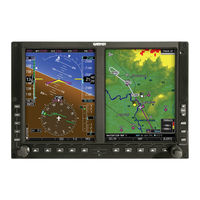
Garmin G500H Pilot's Manual (440 pages)
Brand:
Garmin
| Category:
Avionics Display
| Size: 25.4 MB
Table of Contents
Table of Contents
3
System Description
29
System Overview
30
Display Layout
31
Display Configurations
32
System Functions
35
Pilot Interface
36
Unit Power
36
Power off Options
36
SD Card Slot
37
Touchscreen
38
Keys
39
Menus
40
Lists
41
Tabs
41
Keypads
42
Control Knobs
43
Knob Function Indicators
44
Screen Captures
45
Color Conventions
46
Databases
47
Database Effective Cycles
48
Active and Standby Databases
49
Manual Updates
49
Database Update Page
49
Automatic Updates
51
Database Concierge
52
Database SYNC
54
Chart Streaming
55
Connectivity
56
Flight Stream 510 Setup
56
Bluetooth Setup
57
Managing Paired Devices
57
Wi-Fi Setup
58
Connecting to Wi-Fi
58
Viewing Wi-Fi Information
59
Pilot Settings
60
Display Brightness Control
60
Automatic Brightness Control
60
Manual Brightness Control
60
System Status Page
61
Click Volume
61
Clock
61
Weather Display Shortcut
61
Unit Selections
62
Crew Profiles
63
Crew Profile Settings
63
Crew Profile Management
65
System & Function Advisories
67
Warnings & Cautions
67
Alerts Types
67
System Messages
67
Alert Annunciations
68
Pop-Up Alerts
69
Aural Alerts
71
Advisories
72
Audio Advisories
73
Battery Advisories
73
Database Advisories
74
Emergency Descent Mode Advisories
75
Engine System Advisories
76
Terrain Advisories
77
Traffic System Advisories
78
Satellite Service Advisories
79
PFD Advisories
79
System Hardware Advisories
82
Weather Service Advisories
83
LRU Failure Annunciations
84
PFD Failure Annunciations
84
EIS Failure Annunciations
85
Logs
86
Flight Data Logging
86
Exporting to SD Card
88
Streaming to Garmin Pilot
90
Exceedance Logging
91
Exceedance Alerts
93
Exceedance Details
94
Exporting to SD Card
94
Compatible Equipment
95
Line Replaceable Units
95
LRU Status
96
Integrated Standby Instrument - Piston Aircraft
96
Standby Instruments
97
PFD Controller
98
Backup Battery
99
Adc & Ahrs
99
PFD Adapter
100
Autopilot
100
Weather & Music
103
Engine Monitoring
106
Magnetometer
107
Navigation/Fms
107
Temperature Probe
107
Radar Altimeter
108
Traffic
109
2 Primary Flight Display
111
PFD Setup
113
Synchronization Options
115
Reference Bugs and Controls
116
Flight Instruments
119
Attitude Indicator
121
Attitude Sync, Rotorcraft Only
123
Extreme Attitude Indications
124
VNAV Guidance Indications
126
Airspeed Indicator
127
Reference Markings
129
Reference Speeds
130
Barometric Altimeter
131
Fast/Slow Indicator
131
Adjusting Barometric Pressure
134
Adjusting Selected Altitude
135
Temperature Compensation Minimums
136
MDA/DH Alerting
137
Vsi
138
Selected Vertical Speed
140
Horizontal Situation Indicator
141
Setting the Heading Bug
143
HSI Annunciations
144
CDI
147
Course Pointer Types
148
Cross Track Error Indication
148
CDI Source Selection
149
Selected Course with GPS
150
Selected Course with VOR/LOC
150
Automatic Source Selection
151
Auto-Slewing
152
Ldi
153
Reverse Sensing Correction
153
VDI
154
VNAV Deviation Indications
155
CDI/VDI Preview
156
Bearing Pointers
159
Supplemental Flight Data
159
GPS NAV Status Field
161
Relative Wind Data
162
Temp/Dalt Display
163
DME Display
164
Marker Beacon Symbols
165
Radar Altitude
165
Clock/Timer
166
RA Test
166
3 Advanced Features
167
HSI Map
168
HSI Map Overlays
170
Overlay Status Icons
172
Map Display, GDU 700L
173
GDU 700L Map Overlays
175
Svt
178
SVT Setup
178
SVT Features
179
Autopilot
186
Gpss
186
Flight Director
188
Altitude Preselect Functions
190
Low Bank Mode
191
Servo Heading Reference
191
Mode Annunciations
192
Autopilot Preflight Test
196
4 Multi-Function Display
197
Multi-Function Display
198
Mfd Setup
199
MFD Resize Option
200
Nearest Airport Criteria
200
Map
201
Map Interactions
204
Map Overlays
207
Overlay Controls
207
Map Detail
210
Map Setup
211
Chart Setup
224
Charts
224
Chart Selection
226
Aircraft Position Icon
227
Active Flight Plan
228
Edit Data Fields
229
Collapse All Airways
230
Flight Plan Map Indications
231
Waypoints
232
Waypoint Information
234
Waypoint Selection
237
Siriusxm Audio Entertainment
239
Browse Music Channels
240
Siriusxm Audio Activation
240
External Video
242
SD Video Setup
243
5 Weather Awareness
245
Weather Awareness
246
Weather Display
246
Weather Products
248
Datalink Weather
249
Weather
250
Weather Product Age
252
Precipitation
253
Clouds
256
Echo Tops
256
Lightning
257
Metars and Tafs
258
Cell Movement
259
Airmets
260
Center Weather Advisory
262
Sigmets
262
County Warnings
263
Cyclone/Hurricane Track
263
Airep/Pireps
264
City Forecast
265
Surface Analysis
265
Winds Aloft
266
Icing
267
Turbulence
268
Freezing Levels
269
Tfrs
270
Siriusxm
271
FIS-B Weather
274
Connext Weather
278
Stormscope Page
283
Stormscope Setup
284
Airborne Weather Radar
286
Weather Radar Page
286
Weather Radar Setup
288
Radar Modes
292
Radar Controls
296
Radar Alerts
300
6 Traffic Awareness
301
Traffic Awareness
302
Traffic Display
302
Traffic Page
303
Traffic Setup
305
Tis-A
307
Traffic Types
307
Tas/Tcas I
309
Tcas II
311
Ads-B
315
Traffic Alerts
320
7 Terrain Awareness
321
GPS Altitude for Terrain
322
Terrain Awareness
322
Terrain Configurations
322
Database Limitations
324
Terrain Display
325
Terrain Page
325
Terrain Setup
327
Terrain Proximity
328
Alert Types
333
Terrain Alerting
333
Terrain-FLTA
339
Taws-B
343
External TAWS/HTAWS
347
8 Fuel & Engine Indicating System
355
EIS Display
356
Fuel & Engine Indicating System
356
Reciprocating Engines
356
EIS Setup
358
EIS Functions
360
Gauges
362
Lean Assist Mode
369
EIS Operations
373
Engine Advisories
375
EIS Display
376
Turbine Engines
376
EIS Setup
378
EIS Functions
379
Gauges
380
EIS Operations
394
Engine Advisories
396
Electrical Gauges
397
Fuel Computer
398
Engine Alerts
401
Abnormal Operations
404
Backup Instruments
404
Display Backup
404
Backup Battery
411
AHRS & ADC Failures
416
HSI Failure Modes
423
Emergency Descent Mode
427
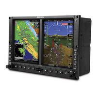
Garmin G500H Pilot's Manual (366 pages)
Brand:
Garmin
| Category:
GPS
| Size: 32.7 MB
Table of Contents
Table of Contents
9
1 System Overview
17
System Description
17
Standard System Line Replaceable Units (LRU)
18
Gdu 620
19
Air Data Computer (ADC)
19
Attitude Heading Reference Syste (AHRS)
20
Gmu 44
23
Garmin Navigator Interface
23
Gea 71
23
Optional Line Replaceable Units (LRU)
24
GDL 88H (Optional)
24
Weather Radar
24
Stormscope ® (Optional)
24
GSR 56 (Optional)
24
GDL 69/69A (Optional)
25
GAD 43/43E (Optional)
25
GTX 330/330D (Optional)
26
System Power up
27
International Geomagnetic Reference Field
29
System Operation
30
Pilot Controls
30
PFD Knob
30
PFD Bezel Keys
31
MFD Knobs
33
MFD Bezel Keys
33
Using the Soft Key Controls
34
Using the
35
System Settings
36
Display Backlighting
39
2 Primary Flight Display (PFD)
41
PFD Soft Keys
42
Airspeed Indicator
46
Markings
47
Reference Speeds
47
Attitude Indicator
48
Extreme Attitude
50
Altimeter
52
Setting the Altitude Bug and Alerter
52
Altitude Alerting
53
Changing Barometric Setting
53
Minimum Descent Altitude/Decision Height Alerting
54
Vertical Speed (V/S) Indicator
56
Horizontal Situation Indicator
57
Setting the Heading Bug
58
Turn Rate Indicator
59
Course Deviation Indicator
59
Changing CDI Sources
60
Changing CDI Course
61
Vertical Deviation Indicator (VDI)
62
Auto-Slewing
63
Supplemental Flight Data
65
Bearing Pointers
65
Temperature Display
67
Wind Vectors
67
DME Indication
68
Marker Beacon Annunciations
68
Miscompare Annunciations
69
Attitude (ATT) Sync
70
2.10 Radar Altimeter
72
3 Multi-Function Display (MFD)
75
Navigation Map
76
Default Navigation Map Page
77
Map Overlay Icons
77
Selecting
78
Changing the Navigation Map Range
78
Decluttering Map
78
Panning
80
Selecting Items on the Map
81
Measuring Distances
82
Customizing Navigation Map
83
Map Setup
83
Map Feature Options
85
Weather Feature Options (Optional)
94
Traffic Feature Options (Optional)
97
Aviation Feature Options
98
Split Screen (Optional)
102
Aux Mode Pages
103
System Settings
103
Display Brightness
104
Airspeed Reference Marks
105
PFD Options - Wind Vector
106
PFD Options - Nav Status
107
Temperature Reference
107
Synchronization (Dual Installations Only)
108
Date and Time
110
MFD Display Units
111
System Display Units
112
Sirius XM Satellite Radio XM Information (Optional)
113
Sirius XM Satellite Radio XM Entertainment Radio (Optional)
114
System Status
115
Database Sync Operation
116
Resolving Database Conflicts
120
ADS-B/FIS-B Status (Optional)
122
External Video (Optional)
123
Select Video Source
123
Zoom
124
Panning
124
Setup
124
Restore Defaults
126
Full Screen
127
Position Reporting (Optional)
128
Status
128
Report Type
128
Iridium Phone Operation (Optional)
131
Status
131
Managing the Phone Book
133
Phone Volume
136
Making a Phone Call
137
Answering a Phone Call
138
Flight Plan
139
Active Flight Plan Page
139
Active Flight Plan Detail
140
Active Flight Plan Options
140
Setting the Altitude Minimums Alerter
141
Waypoint Information Page
142
Selecting a Waypoint
143
Waypoint/Runway/Frequency Information Detail
145
Airport Directory
148
Waypoint Weather Information (Optional)
149
Charts Page (Optional)
150
4 Hazard Avoidance
151
Terrain Configurations
151
Terrain Scale
153
Terrain Proximity
153
Displaying Terrain Proximity
155
Terrain Proximity Page Display on the Terrain Page
155
Terrain Proximity Page Display on a Navigation Map Page
156
Terrain Proximity Page 120° Arc or 360° Rings
156
Terrain Proximity Page Aviation Data
158
Terrain Proximity Limitations
159
System Status
159
External H-TAWS
160
Garmin Terrain-HSVT™ (Optional)
161
Garmin Terrain-HSVT™ Page Aviation Data
163
Inhibiting/Enabling Garmin Terrain-HSVT™ Alerting
164
Garmin Terrain-HSVT™ Reduced Protection (RP) Mode
165
Synthetic Vision Alerts and Annunciations
167
Mute Caution Alerts
169
SVT Alerts When Is Terrain Inhibited
170
Traffic Systems
171
TAS/TCAS 1 Traffic (Optional)
171
Displaying and Operating Traffic (TAS Systems)
172
Switching from Standby Mode to Operating Modes
172
Range Ring
173
Altitude Display
173
TAS/TCAS Symbology
174
Traffic System Status
175
Traffic Pop-Up
177
TIS Traffic (Optional)
178
Traffic Map Page
178
TIS Symbology
180
TIS Limitations
181
TIS Alerts
183
Traffic Pop-Up
184
TIS System Status
185
ADS-B Traffic (Optional)
187
Target Selection
188
Status
189
Motion Vector
190
XM WX Satellite Weather (Optional)
192
Using XM WX Satellite Weather Products
192
Customizing the XM WX Satellite Weather Map
193
XM Weather Symbols and Product Age
195
XM WX Weather Symbols and Product Age
195
XM Weather Legends
197
XM Nexrad
199
Reflectivity
201
NEXRAD Limitations
201
XM Weather Page Map Orientation
202
NEXRAD Data Viewing Range
202
NEXRAD Legend
203
NEXRAD Source
204
XM Echo Tops
205
XM Cloud Tops
207
XM WX Satellite Lightning
209
XM Sigmets and Airmets
210
XM Pireps
212
XM Metars
213
XM Winds Aloft
215
XM Surface Analysis and City Forecast
217
XM County Warnings
219
XM Tfrs
220
XM Cell Movement
222
XM Aireps
224
XM Cyclone
226
XM Freezing Level
227
XM Icing
228
XM Turbulence
229
GFDS Weather (Optional)
230
Register with GFDS
232
Deactivate Unit Registration with GFDS
233
Using GFDS Satellite Weather Products
234
Customizing the GFDS Weather Map
234
Weather Page Map Orientation
236
GFDS Data Request
237
GFDS Data Request Coverage
238
GFDS Data Request Auto Request
240
GFDS Data Request Manual Request
241
GFDS Data Request Status Window
241
Precipitation (PRECIP) Data Viewing Range
242
PRECIP Legend
243
GFDS Infrared Satellite (IR SAT) Data Viewing Range
244
Data Link Lightning (DL LTNG) Data Viewing Range
245
Sigmets and Airmets (SIG/AIR)
246
Airep/Pirep
248
Metars
250
Winds Aloft
253
GFDS Tfrs
255
FIS-B Weather (Optional)
257
NEXRAD Abnormalities
257
NEXRAD Limitations
257
NEXRAD Intensity
258
Nexrad
258
NEXRAD Weather Setup
259
Weather Page Map Orientation
259
NEXRAD Data Viewing Range
259
NEXRAD Legend
260
NEXRAD Source
261
Sigmets and Airmets (SIG/AIR)
263
Airep/Pirep
266
Metars
268
Winds Aloft
270
FIS-B Tfrs
271
FIS-B Product Times
272
Stormscope
273
5 Additional Features (Optional)
275
Viewing Flitecharts and Chartview
276
Chartview (Optional)
277
Flitecharts
278
Determining Chart Database Type, Coverage, and Currency
279
Selecting a Chart
281
Selecting Flitecharts or Chartview
281
Selecting a New Chart by FPL, NRST, or RECENT
282
Selecting a Chart Manually
282
Chart Auto-Selection
283
Using Charts
285
Chart Zooming and Panning
286
Viewing Chart Details in Chartview
287
Setting the Altitude Minimums Alerter
289
Viewing Chart Notams
290
Day/Night View
291
Safetaxi
292
Using Safetaxi
293
Decluttering
293
Hot Spot Information
293
Safetaxi ® Cycle Number and Revision
295
Sirius XM Satellite Radio Entertainment
296
Activating Sirius XM Satellite Radio Services
296
Sirius XM Satellite Radio Information
298
Sirius XM Satellite Radio Entertainment Radio
299
Channel Categories
300
Selecting a Sirius XM Satellite Radio Channel
301
Sirius XM Satellite Radio Volume
302
Sirius XM Satellite Radio Channel Presets
303
GDL 69/69A Data Link Receiver Troubleshooting
304
Garmin Synthetic Vision Technology (SVT™) (Optional)
305
Garmin SVT™ Operation
307
Activating and Deactivating Garmin SVT
308
Garmin SVT™ Features
309
Flight Path Marker (FPM)
309
Zero-Pitch Line
309
Horizon Heading
310
Airport Signs
310
Runway Depiction
311
Traffic
312
Obstacles
313
Field of View
314
Unusual Attitudes
316
6 Annunciations and Alerts
319
Alerts
319
System Status
332
7 Symbols
333
Map Page Symbols
333
Safetaxi ™ Symbols
334
Traffic Symbols
334
Terrain Obstacle Symbols
336
Basemap Symbols
337
Map Tool Bar Symbols
338
Miscellaneous Symbols
339
8 Glossary
341
Appendix A SD Card Use and Databases
349
Jeppesen Databases
351
Updating the Jeppesen Aviation Database
351
Garmin Databases
353
Updating Garmin Databases
355
Index
357
Garmin G500H Reference Manual (92 pages)
cockpit
Brand:
Garmin
| Category:
GPS
| Size: 4.42 MB
Table of Contents
Aviation Limited Warranty
3
Table of Contents
9
Warnings, Cautions, & Notes
11
Introduction
11
Primary Flight Display (PFD)
12
Airspeed Tape
14
Altitude Tape
15
Barometric Pressure
15
Minimums Bug (Barometric or Radar Altimeter)
16
Altitude Bug
18
Wind Vectors
19
Vertical Speed (V/S)
19
Vertical Deviation Indicator (VDI)
20
Temperature Display
20
DME Indication
21
Clock/Timer
21
Attitude Indicator
22
Horizontal Situation Indicator (HSI): Aircraft Heading
23
Adjusting the Course Pointer
24
HSI Bearing Pointers
24
Gps Mode
25
Additional Features
27
Garmin Terrain-HSVT ™ (Optional)
27
Displaying Garmin Terrain-HSVT ™ Terrain
28
Displaying Heading on the Horizon
28
Displaying Airport Signs
28
Multi-Function Display (MFD)
29
Page Navigation - Moving between Pages
30
Changing Settings Within a Page
30
Default Map Page
30
MFD Soft Key Map
31
Map Group
32
Navigation Map 1 and Navigation Map 2 Pages
32
Decluttering (DCLTR) the Map Pages
33
Split Screen Page (Optional)
37
Traffic Map Page (Optional)
38
Terrain Page
44
WX Group
48
XM Weather Map Pages
48
Customizing the Weather Map
48
Displaying Surface Data
50
Displaying Winds Aloft
50
Weather Legend
50
Garmin Flight Data Services (GFDS) Map Pages
51
FIS-B Weather Map Pages
53
Customizing the Weather Map
53
Aux Group
55
External Video Page (Optional)
55
System Setup Page
56
Setting Time Format
59
Mfd Display Units
60
Setting Temperature Units
61
Data Link
61
XM ® Information Page (Optional)
62
XM ® Radio Page (Optional)
63
Position Reporting Page
65
Iridium® Phone Page
66
Making a Phone Call
67
System Status Page
68
Flight Plan Group
69
Active Flight Plan Page
69
Viewing Your Active Flight Plan
69
Waypoint Information Page
70
Charts Page (Optional)
71
Chart Information
71
Selecting a Chart
71
Selecting Other Charts
72
Viewing Charts and Panning
72
Viewing Details of Chartview™ Charts
73
Setting Minimums
73
Changing Day/Night View
73
Viewing Notams (Chartview Only)
74
Alerts
75
On Screen Alerts
75
TAWS-B Alerts
80
Symbols
82
Map Page Symbols
82
Safetaxi ® Symbols
83
Traffic Symbols
83
Terrain Obstacle Symbols
85
Map Toolbar Symbols
86
XM Weather Toolbar Symbols
87
XM ® WX Weather Symbols and Product Age
88
Miscellaneous Symbols
89
Miscellaneous Symbols
90
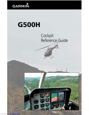
Garmin G500H Cockpit Reference Manual (70 pages)
G500H Cockpit Reference Guide
Brand:
Garmin
| Category:
GPS
| Size: 5.52 MB
Table of Contents
Aviation Limited Warranty
3
Table of Contents
9
Warnings, Cautions, & Notes
11
Introduction
11
Primary Flight Display (PFD)
12
Airspeed Tape
14
Altitude Tape
15
Barometric Pressure
15
Barometric Minimums Bug
16
Altitude Bug
17
Wind Vectors
18
Vertical Speed (V/S)
18
Vertical Deviation Indicator (VDI)
19
Outside Air Temperature (OAT)
19
Attitude Indicator
20
Horizontal Situation Indicator (HSI): Aircraft Heading
21
Adjusting the Course Pointer
22
HSI Bearing Pointers
22
Gps Mode
23
Additional Features
25
Garmin Terrain-HSVT (Optional)
25
Displaying Garmin Terrain-HSVT ™ Terrain
26
Displaying Heading on the Horizon
26
Displaying Airport Signs
26
Multi-Function Display (MFD)
27
Page Navigation - Moving between Pages
28
Changing Settings Within a Page
28
Default Map Page
28
MFD Soft Key Map
29
Map Group
30
Navigation Map 1 and Navigation Map 2 Pages
30
Decluttering (DCLTR) the Map Pages
31
Split Screen Page (Optional)
34
Traffi C Map Page (Optional)
35
Terrain Page
39
WX Group
43
WX Data Link Map Pages
43
Customizing the Weather Map
43
Displaying Surface Data and Winds Aloft
45
Aux Group
46
External Video Page (Optional)
46
System Setup Page
47
Setting Time Format
48
Mfd Display Units
49
XM ® Information Page (Optional)
51
XM ® Radio Page (Optional)
52
Selecting a Channel
52
System Status Page
54
Flight Plan Group
55
Active Flight Plan Page
55
Viewing Your Active Flight Plan
55
Waypoint Information Page
56
Charts Page (Optional)
57
Change Day/Night View
57
Viewing Charts and Panning
57
Viewing Notams
58
Selecting a Chart
58
Selecting Other Charts
59
Chart Information
60
Alerts
61
On Screen Alerts
61
Terrain-HSVT Alerts
62
Symbols
63
Map Page Symbols
63
Safetaxi ® Symbols
64
Traffi C Symbols
64
Terrain Obstacle Symbols
65
Map Toolbar Symbols
65
XM ® Weather Toolbar Symbols
66
Miscellaneous Symbols
67
Related Products
Garmin GPS 12 MAP
Garmin GPS 165TSO
Garmin GPS 35 USB
Garmin GPS 12H
Garmin GPS 55 AVD
Garmin GPS35-LVS
Garmin GMA 340H
Garmin GTN 625
Garmin GTN 635
Garmin G3X TOUCH Single 10
Garmin Categories
GPS
Watch
Car Navigation system
Avionics Display
Marine GPS System
More Garmin Manuals