beautypg.com
Manuals
Brands
Garmin Manuals
GPS
GPSmap 585 Plus
Garmin GPSmap 585 Plus Manuals
Manuals and User Guides for Garmin GPSmap 585 Plus. We have
1
Garmin GPSmap 585 Plus manual available for free PDF download: Owner's Manual
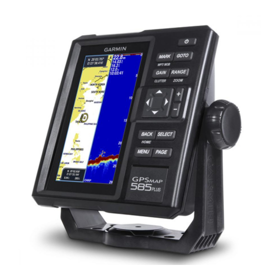
Garmin GPSmap 585 Plus Owner's Manual (68 pages)
Brand:
Garmin
| Category:
GPS
| Size: 9.11 MB
Table of Contents
Table of Contents
3
Introduction
9
GPSMAP 585 Plus Dimensions
9
Device Overview
9
Keys
10
Contacting Garmin Product Support
10
Inserting Memory Cards
10
Software Update
11
Loading the New Software on a Memory Card
11
Updating the Device Software
11
Selecting the Transducer Type
11
Zooming in and out of the Chart
11
Panning on the GPSMAP 585 Plus
11
Adjusting the Backlight
11
Changing the Color Mode
12
Configuring the Display Colors
12
Setting the Beeper
13
GPS Satellite Signal Acquisition
13
Home Screen
13
Customizing the Home Screen
13
Adding a New Layout to the Home Screen
14
Page Shortcuts
14
Editing the Page Shortcuts
15
Adding the Numbers or Trip Page
15
Numbers
15
Trip Page
15
Adding the Data Graphs Screen
15
Adding the Depth Data Graph Page
16
Adding the Temperature Data Graph Page
16
Data Fields
16
Sonar
16
Full Screen Sonar
16
Garmin Clearvü Sonar View
17
Traditional 50/77/200 Khz Sonar
18
CHIRP Sonar
18
Clearvü Scanning Sonar
18
Split-Screen Frequency
19
Shift-Zoom View
19
Adjusting the Zoom
20
Bottom Lock
20
Shift Zoom
21
Auto
21
Reducing the Clutter
22
Pausing the Sonar Display
22
Creating a Mark or Waypoint on a Sonar Screen Using Your Present Location
22
Creating a Waypoint on a Sonar Screen Using a Different Location
22
Sonar Frequencies
22
Selecting Frequencies
23
Creating a Frequency Preset
23
Sonar Gain
24
Setting the Gain Automatically
24
Setting the Gain Manually
25
Adjusting the Range of the Depth Scale
25
Sonar Setup
25
Showing and Adjusting the Depth Line
25
Setting the Scroll Speed
26
Sonar Appearance Settings
26
Advanced Sonar Settings
27
Interference
28
Surface Noise
28
Color Gain
29
Overlay Numbers Settings
29
Tvg
29
Charts and 3D Chart Views
30
Compass
30
Depth and Water Temperature Graphs
30
Navigation Chart and Offshore Fishing Chart
31
Chart Symbols
31
Viewing Location and Object Information on a Chart
32
Navigating to a Point on the Chart
32
Viewing Details about Navaids
32
Chart and 3D Chart Settings
33
Marks, Waypoints, and Tracks on the Charts and Chart Views
33
Other Vessels on the Charts and Chart Views
33
Navigation and Fishing Chart Setup
34
Overlay Numbers
34
Showing a Navigation Inset
35
Chart Appearance Settings
35
Fish Eye 3D Settings
36
Garmin Quickdraw™ Contours Mapping
36
Accessing the Garmin Quickdraw Community
39
Sharing Your Garmin Quickdraw Contours Maps with the Garmin Quickdraw Community
39
Downloading Garmin Quickdraw Community Maps
40
Creating a Mark or Waypoint on a Sonar Screen Using Your Present Location
40
Waypoints and Marks
40
Creating a Mark or Waypoint
41
Creating a Waypoint on a Sonar Screen Using a Different Location
41
Deleting a Waypoint or an MOB
41
Editing a Saved Waypoint
41
Marking and Navigating to a man Overboard Location
41
Navigating to a Waypoint
41
Copying Waypoints, Routes, and Tracks to a Memory Card
42
Creating and Navigating a Route Using the Waypoint Map
42
Deleting All Waypoints
42
Routes
42
Sharing Waypoints and Routes Across Devices
42
User Data Settings
42
Creating and Navigating a Route Using the Waypoint List
43
Creating and Navigating a Route Using the Waypoint Map
43
Editing a Saved Route
43
Viewing a List of Routes
43
Browsing for and Navigating a Saved Route
44
Clearing the Track
44
Configuring the Recording Interval of the Track Log
44
Deleting a Saved Route
44
Deleting All Saved Routes
44
Managing the Track Log Memory During Recording
44
Setting the Color of the Track
44
Track
44
Adjusting the AIS Radar Range
45
AIS Radar
45
Deleting All Saved Waypoints, Routes, and Tracks
45
Creating an AIS Group
46
Customizing the Display of the AIS Radar Screen
46
Enabling AIS Transmission Test Alerts
46
Marking a Waypoint on the AIS Radar Screen
46
Viewing a List of AIS Threats
46
Setting the Safe-Zone Collision Alarm
47
VRM and EBL
47
Showing the VRM and EBL
47
AIS Radar Appearance Settings
48
Highway Page
48
Measuring the Range and Bearing to a Target Object
48
Opening the Highway Page
48
Auto Guidance
49
Showing and Customizing the Highway Overlay Numbers
49
Adjusting the Distance from Shore
50
Auto Guidance Path Configurations
50
Digital Selective Calling
52
DSC List
52
Viewing the DSC List
52
Adding a DSC Contact
52
Incoming Distress Calls
52
Navigating to a Vessel in Distress
52
Networked Chartplotter and VHF Radio Functionality
52
Position Tracking
52
Viewing a Position Report
52
Navigating to a Tracked Vessel
53
Creating a Waypoint at the Position of a Tracked Vessel
53
Editing Information in a Position Report
53
Deleting a Position-Report Call
53
Viewing Vessel Trails on the Chart
53
Turning on DSC
52
Individual Routine Calls
53
Selecting a DSC Channel
53
Making an Individual Routine Call
54
Making an Individual Routine Call to an AIS Target
54
Celestial Information
54
Tide, Current, Lunar Calendar, and Celestial Information
54
Viewing Information for a Different Tide Station
54
Device Configuration
55
GPSMAP 585 Plus Settings Menu Tree
55
Lunar Calendar
55
My Vessel Settings
57
Setting the Keel Offset
58
Setting the Water Temperature Offset
59
System Settings
57
System Information
57
Alarms Settings
59
System Alarms
60
Sonar Alarms
60
Calibrating a Water Speed Device
59
Communications Settings
61
NMEA 0183 Settings
61
Unit Settings
61
Navigation Settings
62
Restoring the Factory Default Settings
62
Appendix
63
GPSMAP 585 Plus Specifications
63
Registering Your Device
63
Sun Cover
63
Troubleshooting
64
My Device Does Not Turn on
64
My Sonar Does Not Work
64
My Device Is Not Creating Waypoints in the Correct Location
65
物質宣言
67
Related Products
Garmin DEZL 580LMT-S
Garmin GPSMAP 520s GPSMAP 520
Garmin 531s - Transducer
Garmin dezl 560LMT
Garmin GPSMAP 541/541s
Garmin GPSMAP 555s
Garmin nuvi 52LM
Garmin GPSMAP 527xs Guide
Garmin echoMAP 50s Guide
Garmin GPSMAP 520/520s
Garmin Categories
GPS
Watch
Car Navigation system
Avionics Display
Marine GPS System
More Garmin Manuals