Garmin MX20 Manuals
Manuals and User Guides for Garmin MX20. We have 6 Garmin MX20 manuals available for free PDF download: Pilot's Manual, User Manual, Installation Manual, Quick Reference Manual
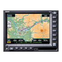
Garmin MX20 Pilot's Manual (152 pages)
color Multi-Function Display
Table of Contents
-
-
Functions13
-
Controls15
-
Menu/Enter15
-
Menu Item16
-
Data Card16
-
Display17
-
-
Terrain18
-
Lightning18
-
Message Flag19
-
Brightness21
-
Power on21
-
Options Menu25
-
-
-
Auto Zoom31
-
Map Scale31
-
Pan32
-
Info32
-
Flight Plan33
-
Invert34
-
Nav Data34
-
-
Airports35
-
-
Vors35
-
Vor Obs36
-
Ndbs37
-
Airspace37
-
Low Airways38
-
High Airways38
-
Water38
-
Roads38
-
Boundaries38
-
Terrain39
-
Obstructions40
-
Traffic40
-
Strikes41
-
-
-
IFR Option42
-
Flight Plan42
-
Invert43
-
Nav Data43
-
Label43
-
IFR Option43
-
Low Airways43
-
High Airways43
-
Load Chart44
-
-
-
Flight Plan45
-
Invert45
-
Nav Data46
-
Label46
-
-
-
-
-
Target Color58
-
Ident58
-
Confirm Code59
-
Operation59
-
-
Set 120061
-
Services61
-
Time61
-
Flight Plan62
-
Display Mode63
-
Text Display63
-
Label63
-
-
-
Text Display78
-
-
Tion
80-
Current83
-
Nexrad83
-
Lightning84
-
Metars84
-
Cloud Tops85
-
Echo Tops85
-
-
Winds Aloft86
-
TFR Lbl86
-
Label86
-
Flight Plan86
-
Legend87
-
Map Detail87
-
Forecast89
-
Airmet90
-
County90
-
Cyclone91
-
Flight Plan91
-
Label91
-
Legend91
-
Map Detail91
-
-
Text92
-
Status93
-
-
Flight Plan96
-
Lightning96
-
System Data97
-
Demo97
-
Self-Test97
-
Strike Test98

Garmin MX20 Pilot's Manual (152 pages)
color Multi-Function display
Brand: Garmin
|
Category: Avionics Display
|
Size: 6.84 MB
Table of Contents
-
Welcome6
-
Functions13
-
Controls15
-
Menu/Enter15
-
Menu Item16
-
Data Card16
-
Display17
-
ADS-B TraffiC18
-
Terrain18
-
Lightning18
-
Message Flag19
-
Brightness21
-
Power on21
-
Options Menu25
-
Auto Zoom31
-
Map Scale31
-
Pan32
-
Info32
-
Flight Plan33
-
Invert34
-
Nav Data34
-
Airports35
-
Vors35
-
Vor Obs36
-
Ndbs37
-
Airspace37
-
Low Airways38
-
High Airways38
-
Water38
-
Roads38
-
Boundaries38
-
Terrain39
-
Obstructions40
-
TraffiC40
-
Strikes41
-
IFR Option42
-
Flight Plan42
-
Invert43
-
Nav Data43
-
Label43
-
IFR Option43
-
Low Airways43
-
High Airways43
-
Load Chart44
-
Flight Plan45
-
Invert45
-
Nav Data46
-
Label46
-
Symbology49
-
Off Scale49
-
TAS Fail50
-
TAS Time-Out50
-
Standby Mode50
-
Self-Test51
-
Filter51
-
Volume51
-
Shield51
-
Filter52
-
Volume52
-
TIS-B TraffiC56
-
Target Color58
-
Confirm Code59
-
Operation59
-
Set 120061
-
Services61
-
Time61
-
Flight Plan62
-
Display Mode63
-
Text Display63
-
Label63
-
Symbology65
-
Flight Plan69
-
Text Display72
-
Viewing Text72
-
Metars75
-
Echo Tops75
-
Label76
-
Flight Plan76
-
Legend77
-
Map Detail77
-
Text Display78
-
Function81
-
Current83
-
Nexrad83
-
Metars84
-
Lightning84
-
Cloud Tops85
-
Echo Tops85
-
Winds Aloft86
-
TFR Lbl86
-
Label86
-
Flight Plan86
-
Legend87
-
Map Detail87
-
Forecast89
-
City89
-
Sigmet89
-
Airmet90
-
County90
-
Cyclone91
-
Label91
-
Flight Plan91
-
Legend91
-
Map Detail91
-
Text92
-
View92
-
Status93
-
Diagnostics94
-
Activation94
-
Flight Plan96
-
Lightning96
-
Strike97
-
Cell97
-
System Data97
-
Demo97
-
Self-Test97
-
Strike Test98
-
Overview99
-
Data Card100
-
Chart Zooming103
-
Chart Panning103

Garmin MX20 User Manual (130 pages)
Multi-Function Display
Table of Contents
-
Welcome5
-
-
Functions11
-
Controls13
-
Data Card16
-
Display17
-
-
Data Flags19
-
Message Flag20
-
-
-
-
Map Scale31
-
Auto Zoom32
-
Pan33
-
Info33
-
Flight Plan35
-
Invert36
-
Nav Data36
-
Airports38
-
Vors38
-
Ndbs41
-
Airspace42
-
Low Airways42
-
High Airways43
-
Water43
-
Roads43
-
Boundaries43
-
Terrain45
-
Obstructions45
-
Traffic46
-
Strikes46
-
-
-
Flight Plan47
-
Invert48
-
Nav Data48
-
Label49
-
Low Airways49
-
High Airways49
-
Load Chart50
-
-
-
Flight Plan51
-
Invert52
-
Nav Data52
-
Label52
-
-
-
Flight Plan93
-
Lightning93
-
System Data93
-
Demo94
-
Self-Test94
-
Strike Test95
-
-
-
Overview96
-
-
Chart Panning102
-
Chart Info102
-
-
Menu Items104
-
Load Current105
-
-
Chart Notams108
-
Invert Option108
-
-
-
System Info119
-
Troubleshooting123

Garmin MX20 Installation Manual (90 pages)
Multi-Function display
Brand: Garmin
|
Category: Avionics Display
|
Size: 3.34 MB
Table of Contents
-
Preferred10
-
Radar10
-
Data10
-
-
-
Installation18
-
-
-
Compass Test46
-
-
-
Display57
-
Electrical57
-
Input58
-
-
Mx20 Rear62
-
Antenna64
-
-
-
Operation67
-
Installation67
-
Gps Antenna67
-
Fis Sensor67
-
Radar Sensor68
-
Taws Sensor68
-

Garmin MX20 Installation Manual (88 pages)
Multi-Function Display
Table of Contents
-
Preferred10
-
Radar10
-
Data10
-
-
-
-
Description15
-
-
-
-
Mx20 Unit21
-
-
Installation44
-
Compass Test47
-
-
Operation65
-
Installation65
-
Gps Antenna65
-
Fis Sensor65
-

Garmin MX20 Quick Reference Manual (2 pages)
Garmin MX 20 aviation-multifunction display: Quick Start
Brand: Garmin
|
Category: Avionics Display
|
Size: 0.54 MB